Flood-Risk
Research Initiative


Floods not only cause great distress to the affected communities, but also result in high costs. For this reason, the Mobiliar Lab for Natural Risks at the University of Bern launched a research initiative entitled “Flood-Risk Research Initiative – From Theory to Practice”. The goal is to offer a sound basis and innovative tools for the sustainable management of flood risks.


Visualisation showing the sensitivity of losses to higher precipitation levels
Interactive map of Switzerland showing how damage increase as flood discharges rise
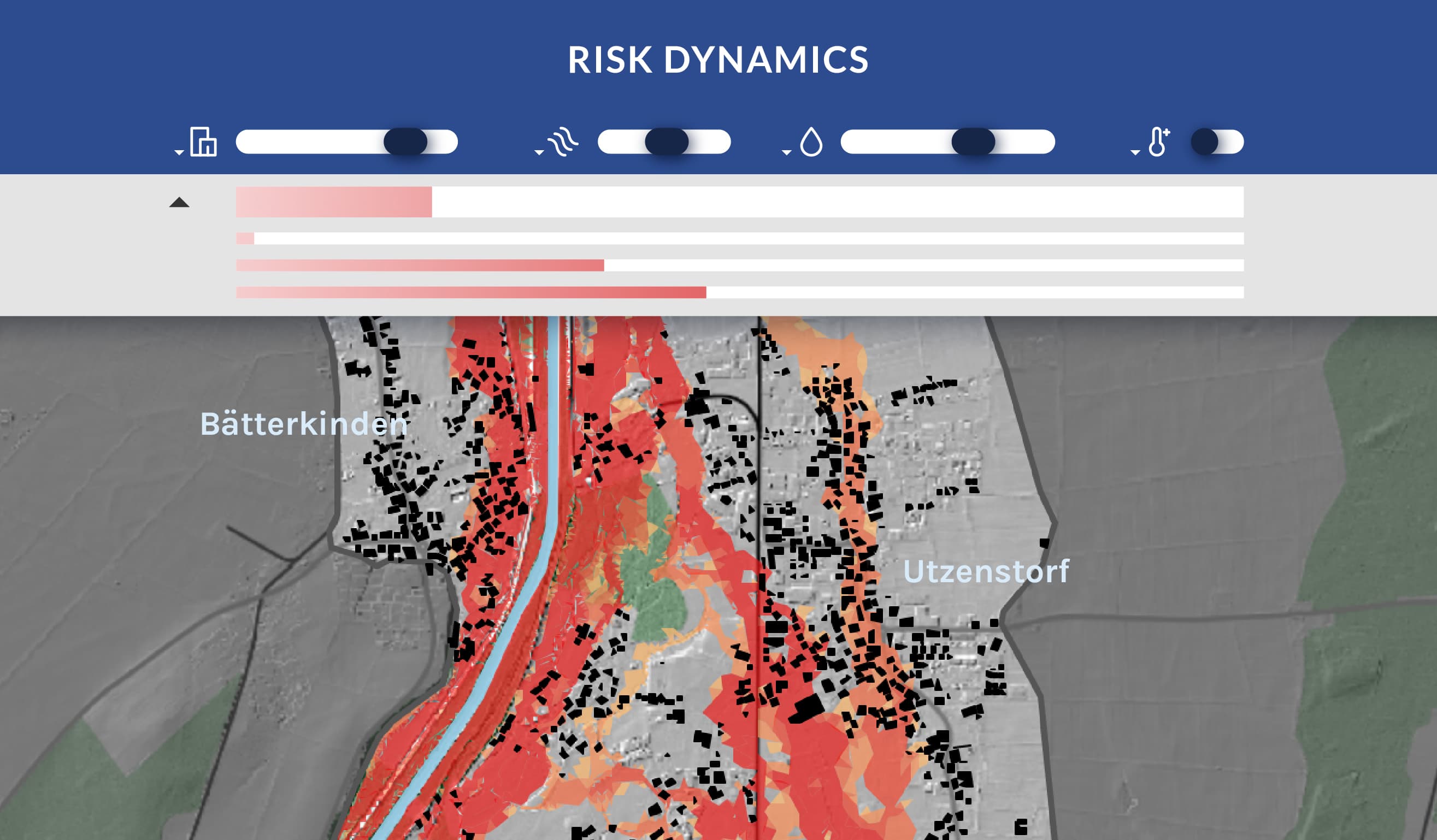
Interactive map of Switzerland that visualises the dynamic impacts of floods
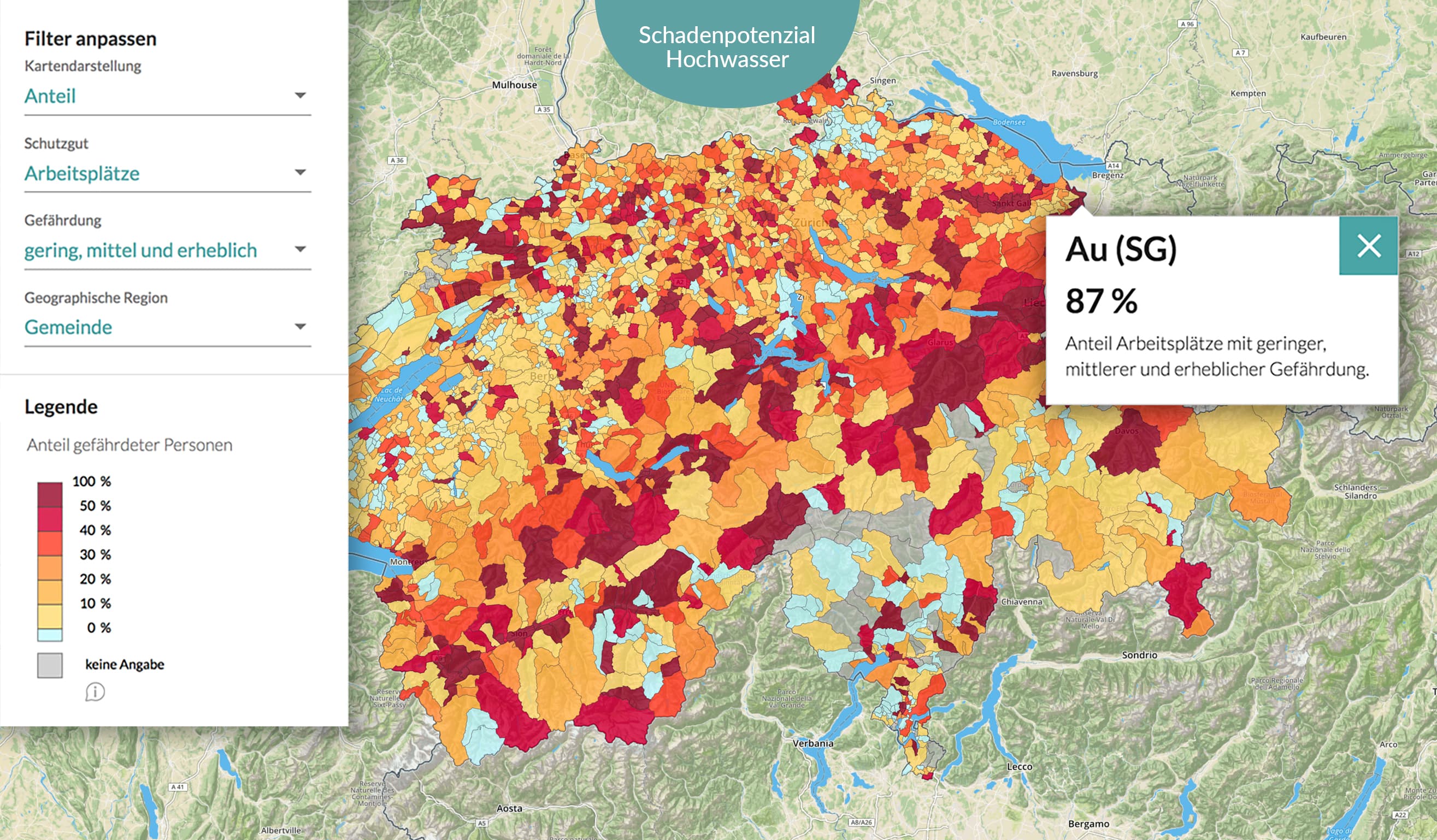
Interactive map of Switzerland illustrating current and future flood damage and showing how it can be influenced
Interactive map of Switzerland showing how many buildings and individuals are potentially exposed to flooding, down to neighbourhood level
Interactive maps of Switzerland showing, at municipal level, how many buildings are potentially exposed to surface water floods and where they are located
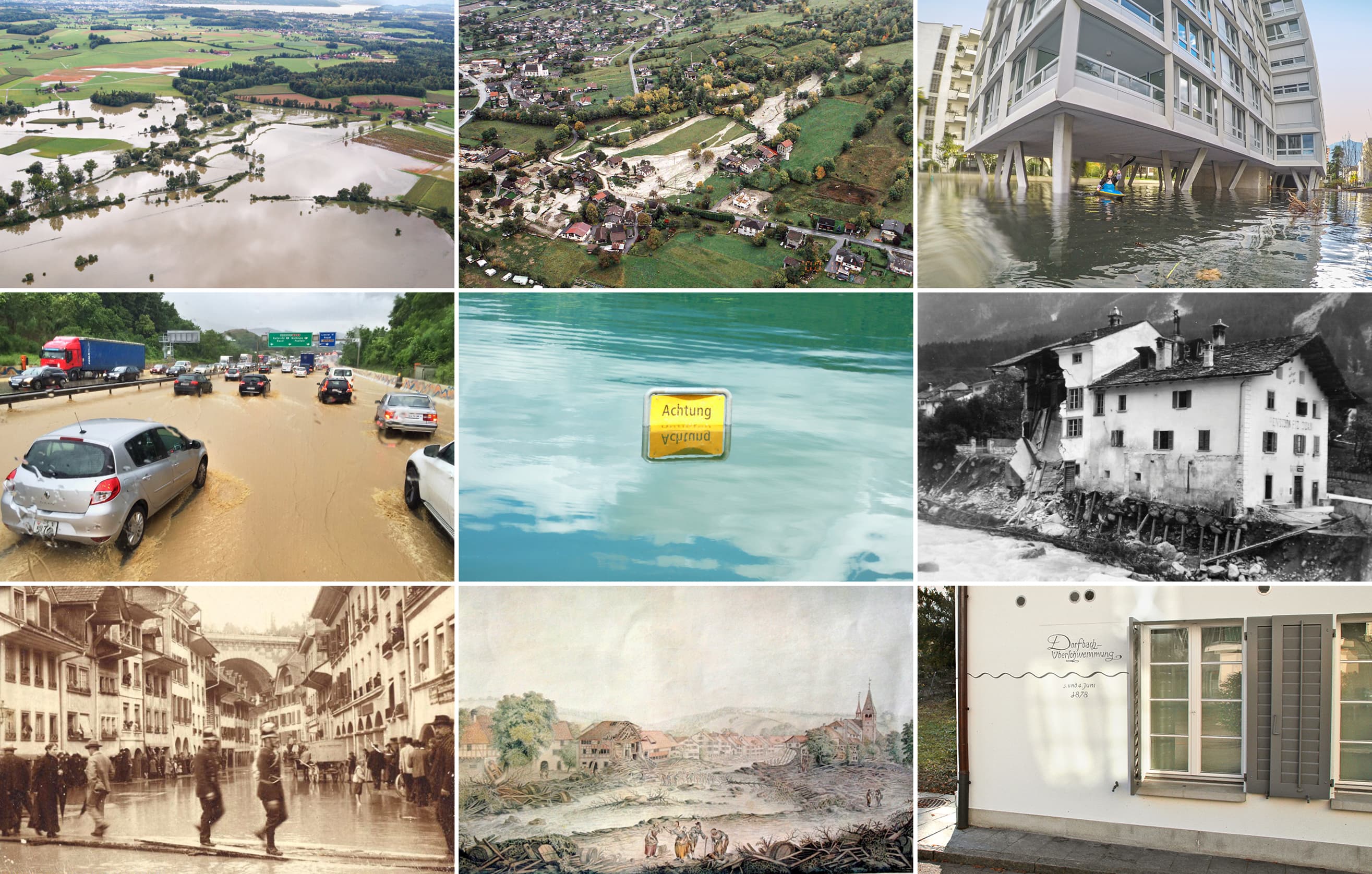
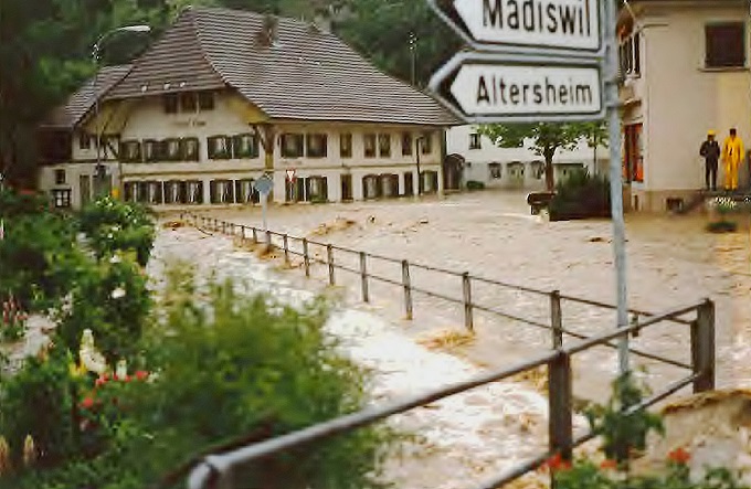
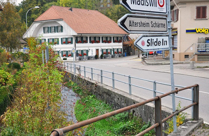
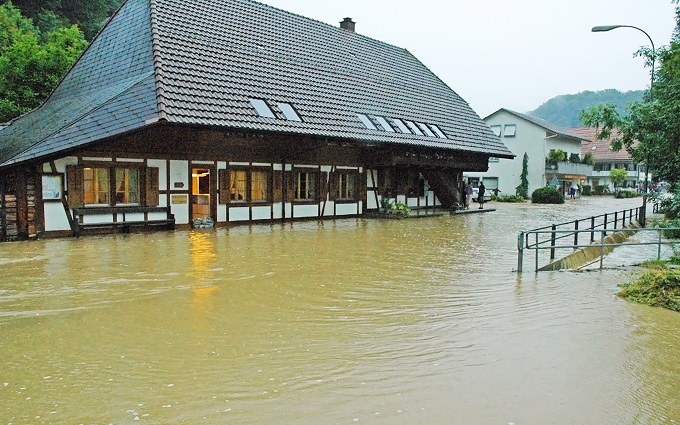
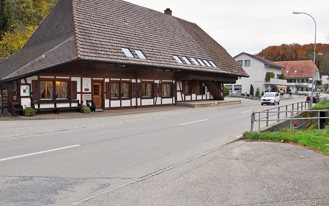
Interactive image repository, covering the whole of Switzerland and containing over 4,000 images of floods from the past 700 years
Interactive tool showing which factors influence the risk of flooding and how these factors change over time for a selected example
The visualisation shows that moderate increases in precipitation levels due to climate change are already leading to significantly higher losses owing to extreme flooding. The visualisation is intended to help decision makers, specialists in natural hazards, engineers and operators of critical infrastructure to develop an awareness of the intensity and consequences of extreme flooding events – both today and in an even warmer climate.
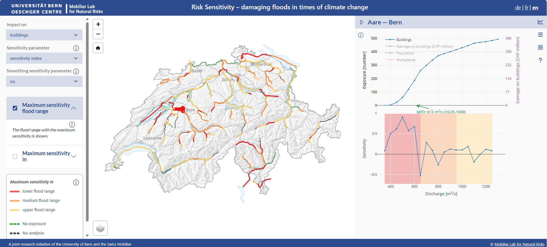
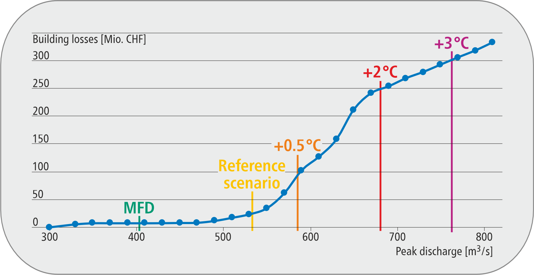
The “Risk Sensitivity” tool shows how damage increase as flood discharges rise, e.g. due to climate change. The tool can support specialists with risk-based considerations such as assessing risks or planning suitable protective measures.

"Think the unthinkable" is a core principle of civil protection. The Flood Dynamics tool can support civil protection in preparing for previously unknown flood events.
Based on a number of precipitation scenarios, the Flood Dynamics tool visualises the direct and indirect effects of extreme precipitation in fast motion – from the rise to the subsiding of floodwaters. The tool is particularly useful in civil protection, both for communicating flood risks and for training purposes.
The damage simulator interprets the hazard map and shows the possible extent of damage to buildings in case of a flood event. Moreover, it illustrates how the possible extent of damage could change in the future and how it can be influenced.


In the area we cover, the flood damage potential is clearly above the Swiss national average. Thanks to the new movable flood barrier, we are even better equipped to deal with this hazard.
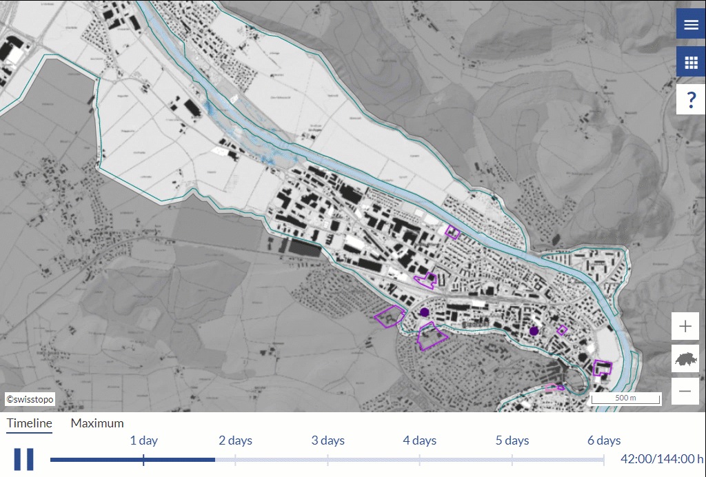
For the first time, the potential damage caused by flooding can be visualised using this tool right across Switzerland – down to individual neighbourhoods. It helps you see how many people or important assets are exposed to floods and where they are located.

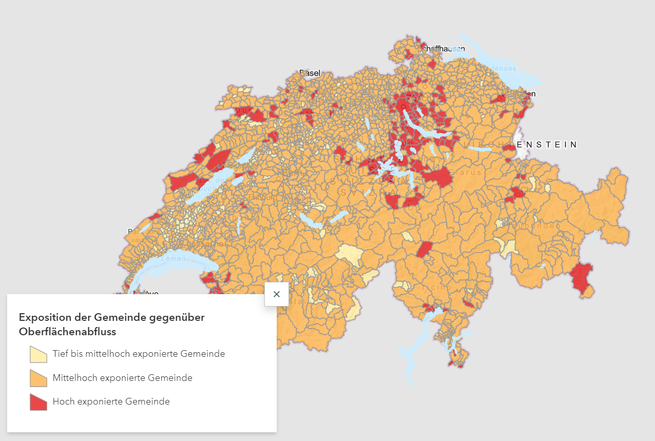
The evaluation enables the potential damage from surface water floods to be identified at municipal level throughout Switzerland for the first time. It shows how many buildings, building assets, employees and other people are exposed to surface water floods and where they are located.


With this tool I can enable the pupils to comprehensively explore the topic of flood risks in a practical manner and to compare their findings with scientific knowledge.
No other natural disaster is costlier to Switzerland than flooding. Over two-thirds of the damage caused by natural disasters is due to floods, which have affected four out of every five Swiss municipalities over the past 40 years. Yet although the new purchase value of all at-risk buildings is around CHF 500 billion and the corresponding damage can amount to several billions, researchers so far have barely addressed the damage caused by flooding, instead focusing mostly on why and how these floods occur.
The research initiative entitled “Flood-risk research initiative – from theory to practice”, conducted by the Mobiliar Lab for Natural Risks, is supplementing traditional research on flooding by examining the damage it causes. Various research projects launched in 2018 aim in particular to develop decision-making resources for flood-risk management.
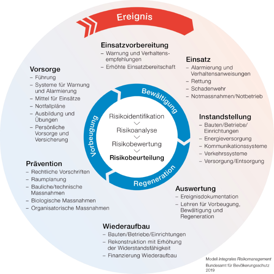
The research initiative is developing practical tools that look into all the eventualities that can arise in the event of flooding, thereby helping cantonal and municipal authorities, other experts and the general public to identify flood risks so that subsequent damage can be minimised. These resources also help prioritise protective measures in full knowledge of the facts and potential risks. The research initiative provides important fundamental data for comprehensive risk management, as required by PLANAT ('Plattform Naturgefahren').
Flooding can be prevented using measures ranging from spatial planning to organisational precautions and by drawing on technical and biological measures, for example protection forest.
However, individuals can contribute to flood protection, too – for instance through measures for property. On the website Schutz-vor-Naturgefahren.ch (in French and German), different methods are presented for specific types of users and needs. For example, the natural disaster checklist contains specific measures usable by homeowners to protect their properties against flooding.
The Mobiliar Lab for Natural Risks is a joint research initiative at the University of Bern’s Oeschger Centre for Climate Change Research and Swiss Mobiliar. The Mobiliar Lab’s research work focuses mainly on floods, storms and hail as well as the associated loss and damage potential, with strong emphasis placed on the practical application of findings.
The Mobiliar Lab was established in 2013, at which time the partners jointly defined the scope of the research’s subject matter. Since then, the researchers have further expanded their focus for practical use.
The independence of teaching and research at the Mobiliar Lab is contractually guaranteed. The Mobiliar Lab is free to choose its research projects and methods as well as any research partners. Furthermore, the Mobiliar Lab acts autonomously in the interpretation of research results. Research results and findings remain the property of the University of Bern and are published through customary scientific channels. Like the University of Bern, the Mobiliar Lab pursues a strategy of free access to its research results.
A joint research initiative:
The research initiative entitled «Flood-risk research initiative – from theory to practice», which was initiated in 2018, encompasses various scientific projects. Please visit the Mobiliar Lab’s website for further information.
Whether floods, storms or hail – the general public takes a great interest in Natural Risks. Researchers from the Mobiliar Lab for Natural Risks regularly answer questions from journalists and are invited to give presentations to community, political and business decision-makers. Expertise gleaned from Natural Risks research is needed at the local, regional and national level. The Mobiliar Lab also actively supports public outreach activities.
University of Bern
Mobiliar Lab for Natural Risks
Hallerstrasse 12
CH-3012 Bern
Phone: +41 31 684 88 39
E-Mail
To make sure you don’t miss the latest news about our research and events, why not subscribe to our newsletter?
Please do not hesitate to share your feedback.
We look forward to your opinions and comments to help us in our research.
Property owners can take flood protection measures for buildings. These measures prevent or reduce damage and can be initiated by the property owners.
Die fünf folgenden Lernmodule zeigen zu den vier Tools Schadensimulator, Schadenpotenzial, Überschwemmungsgedächtnis und Risikodynamik verschiedene Umsetzungsmöglichkeiten zum Thema Hochwasserrisiken – im Schulzimmer und im Freien.
Hochwasserrisiken
Nachstehendes Video veranschaulicht für die Sekundarstufe II, wie der Lerntransfer vom «Verstehen zum Handeln» im eigenen Lebensraum mit Hilfe dieser Tools gelingt. Weiterführende Informationen finden sich hier.


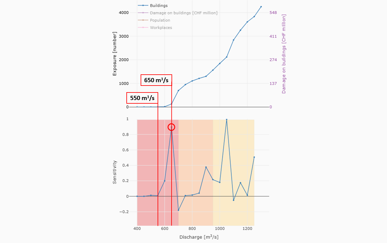
Climate change is very likely to increase flood risk in Switzerland. A warmer atmosphere absorbs more water, resulting in more intense rainfall. In addition, the rise in the zero degree line means that less precipitation is temporarily stored in the form of snow and is discharged immediately instead, especially in winter. This means that higher temperatures and larger amounts of rainfall are resulting in greater runoff into rivers and rising lake levels. The effects of flooding are also increasing as a result. The “Risk Sensitivity” tool quantifies how the impacts of flooding on buildings, people and workplaces in Switzerland are changing as runoff into lakes and rivers increases. This is particularly helpful in identifying discharge threshold levels, which would most likely trigger much more serious consequences if they were surpassed.
Information from the “Risk Sensitivity” tool shows how the effects of flooding increase if the impact of climate change causes flood discharges to rise, for example. It also enables the identification of watercourses, which are particularly sensitive to increased discharges. The tool can therefore assist the authorities in prioritising flood protection projects. This information is also relevant for the emergency services, for example when organising mandatory evacuations in response to discharge forecasts or when planning mobile protection measures at an early stage.
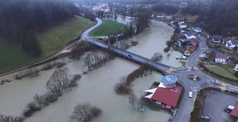
The Muota river in the canton of Schwyz is a 32-kilometre-long river flowing from the Muota Valley into Lake Lucerne. Historical records and documents show that the Muota has flooded repeatedly since time immemorial. The Muota – Brunnen floodplain incorporates the municipalities of Ibach and Ingenbohl.
The highest discharge (HHQ) ever measured from Muota to Brunnen is 433 m3/s. This reading was recorded during the flooding in August 2005 and came very close to a critical threshold level: a scenario involving 10 % more discharge would trigger a fivefold increase in building damage claims at CHF 31 million. A 20 % increase in discharge would increase building damage claims to an estimated CHF 70 million and impact over 1100 people. That equates to a jump of almost 425 % in the number of people affected and more than 1300 % in damage to buildings.
The Emme is an 80-kilometre-long river, which rises at the Hohgant mountain and flows through the cantons of Lucerne, Bern and Solothurn. It ultimately feeds into the Aare river. The “Emme – Burgdorf” section comprises the municipalities from Burgdorf to Bätterkinden.
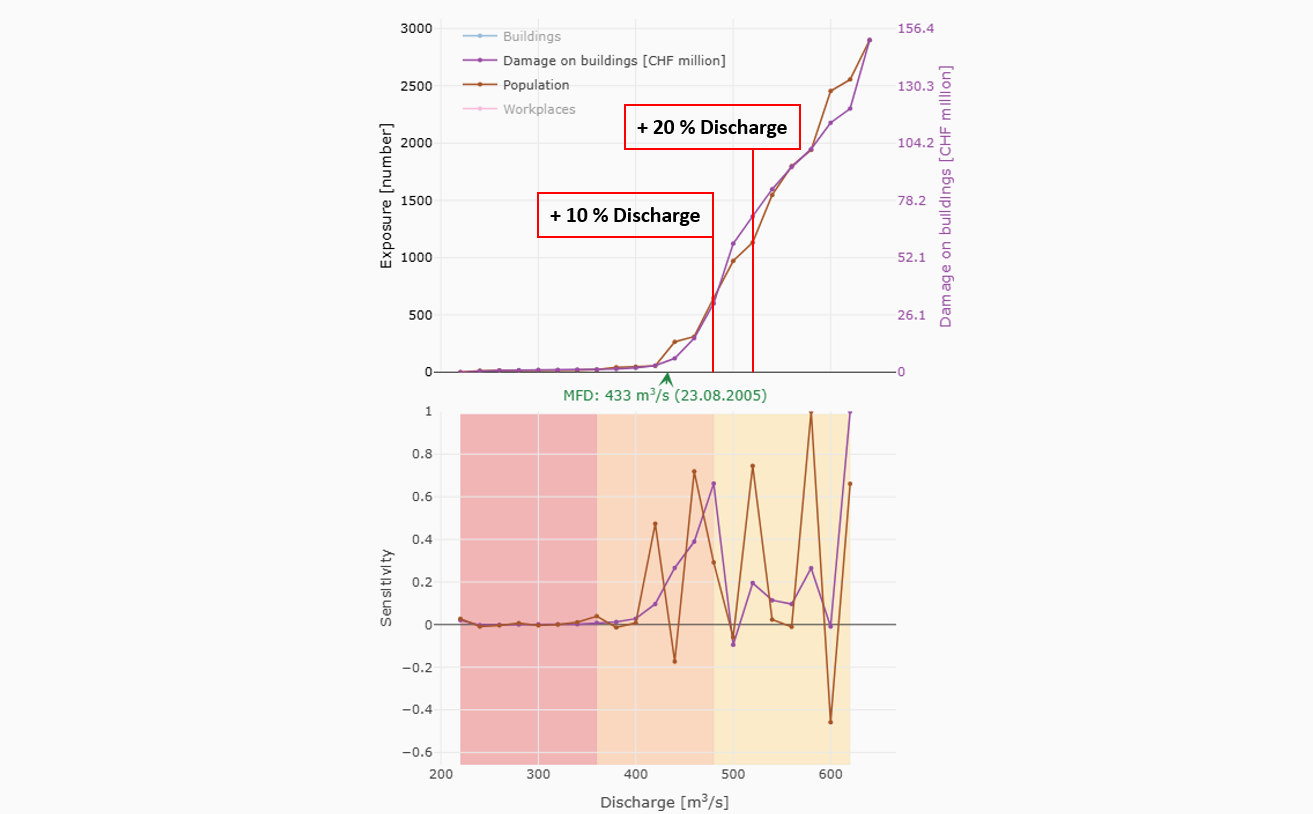
During the 2007 flooding, the Burgdorf section of the Emme flooded a camping site and the warehouse of a logistics centre. At that time the discharge was 550–600 m3/s and thus very close to a critical threshold level. If the discharge were to increase by 10 %, it would lead to a fourfold increase in claims, as the impact explodes disproportionately compared to the discharge. If the discharge were 550 m3/s, seven buildings would be affected, but this figure rises to 132 at 650 m3/s, equivalent to an extremely steep 1885 % increase.
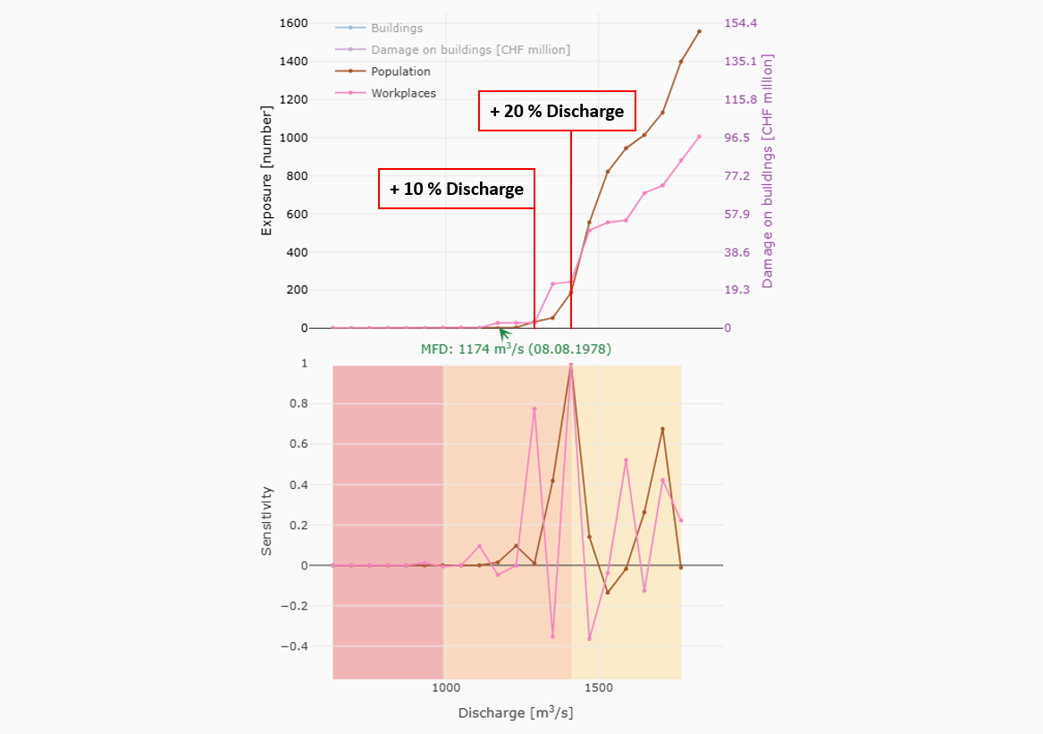
At 134 kilometres, the Thur is eastern Switzerland’s second-longest river and a tributary of the Rhine. It flows through the cantons of St. Gallen, Thurgau and Zurich. The “Thur – Weinfelden” section stretches from Halden to Frauenfeld. The highest flood discharge (HHQ) ever seen to date was in 1978 at 1,174 m3/s. If 10 % more water were to flow into the Thur than in 1978, it would reach a point where the consequences for the “Thur – Weinfelden” section soar disproportionately. This could manifest itself in the number of people affected, for example. At a high water level of 1,174 m3/s discharge as in 1978, no people are actually affected by flooding. If the discharge rises by 10 %, the number of people affected increases to 34, going up to 188 people in the event of a 20 % increase.
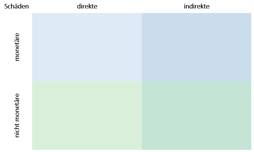
Das Risiko bei Naturgefahren setzt sich aus Gefahrenpotenzial, Schadenpotenzial und Verletzlichkeit zusammen (siehe Begriffsdefinitionen). Hochwasserrisiken betreffen die Mehrheit der Schweizer Bevölkerung. So waren vier von fünf Schweizer Gemeinden in den vergangenen 40 Jahren von Überschwemmungen betroffen. Schweizweit befinden sich im Jahr 2021 rund 300'000 Gebäude mit einem Neuwert von 500 Milliarden Franken in hochwassergefährdeten Gebieten. In diesen Gebäuden wohnen rund 1.3 Millionen Menschen und befinden sich rund 1.1 Millionen Arbeitsplätze.
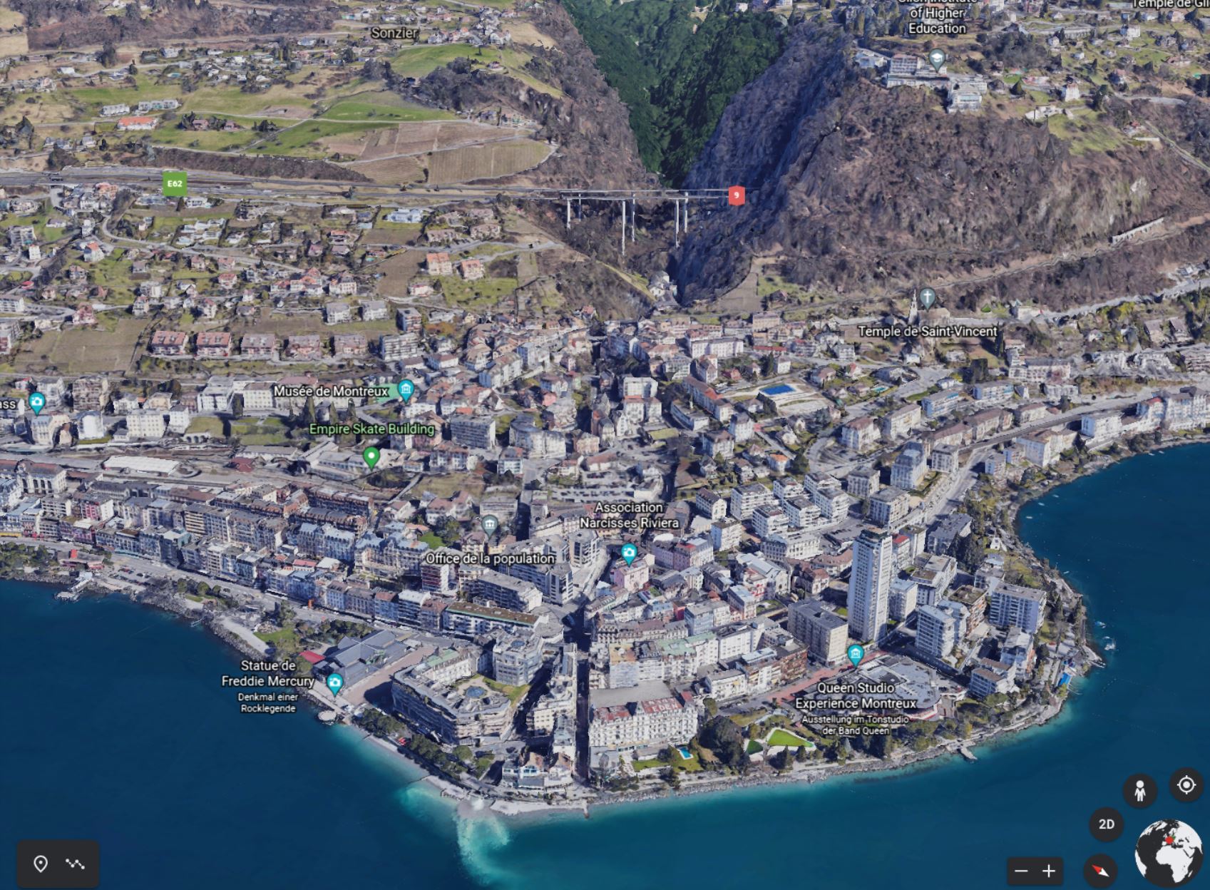
a) Beurteilen Sie die Hochwasserrisiken in Montreux, indem Sie Gebiete mit erhöhtem Gefahren- und Schadenpotenzial markieren sowie Objekte mit erhöhter Verletzlichkeit. Betrachten Sie hierzu Montreux mithilfe von Google Earth so genau wie möglich.
b) Stellen Sie grundlegend wichtige Faktoren für Hochwasserrisiken zusammen und zeigen Sie deren Einfluss auf Gefahrenpotenzial, Schadenpotenzial und Verletzlichkeit auf.
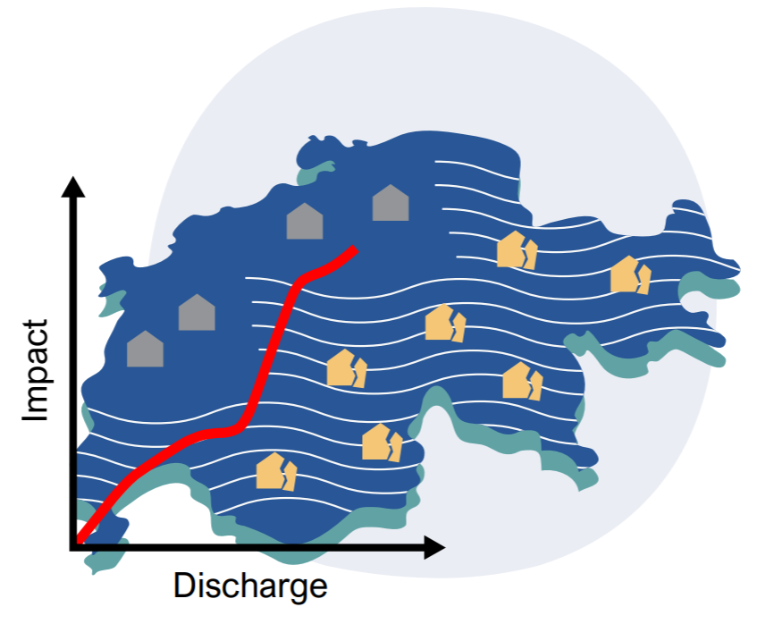
Forschungsarbeiten des Mobiliar Labs zeigen, dass in Gebieten mit geringer Hochwassergefährdung (gelbe Zonen in Gefahrenkarten) die möglichen Schäden und damit auch die Risiken durch Hochwasser stark unterschätzt werden. Der Grund hierzu ist, dass die Schäden bei einzelnen Gebäuden zwar gering sind, die gelben Zonen jedoch häufig stark überbaut sind und so die Gesamtschadensumme im Vergleich mit stärker gefährdeten Zonen sehr hoch ist.
a) Analysieren Sie das Hochwasserrisiko in Ihrer Region, indem Sie alle Faktoren zu Gefahrenpotenzial, Schadenpotenzial und Verletzlichkeit beurteilen (vgl. Zusammenstellung in Lösung zu Aufgabe 1b). Ziehen Sie bei Ihrer Analyse Fotos zu Ihrer Region aus den Tools Überschwemmungsgedächtnis und Sturmarchiv bei und konsultieren Sie das Tool Schadenpotenzial Hochwasser.
b) Ordnen Sie die im Tool Schadenpotenzial Hochwasser erfassten Schutzgüter – z. B. Gebäude, Personen, Schulen, Spitäler – Ihrer Gemeinde der folgenden Abbildung zu. Beurteilen Sie zudem, ob mit diesem Tool alle zu schützenden Güter in Ihrer Gemeinde erfasst werden (siehe auch Erläuterung zur Abbildung).
c) Geländeaufgabe: Überprüfen Sie Ihre Analysen des Hochwasserrisikos (Aufgabe a) und der Schutzgüter (Aufgabe b) in Ihrer Gemeinde durch eine Geländebegehung der gefährdeten Gebiete und passen Sie Ihre Ergebnisse allenfalls an.
d) Geländeaufgabe: Falls Sie im Tool Überschwemmungsgedächtnis Bilder zu Ihrer Gemeinde finden, suchen Sie diese Standorte ebenfalls auf, fotografieren Sie mit dem gleichen Blickwinkel die aktuelle Situation und beurteilen Sie vor Ort, wie sich die Faktoren für Hochwasserrisiken seither verändert haben. Falls Sie zudem eigene Bilder von Hochwassersituationen zu Ihrer Gemeinde haben, können Sie diese im Tool hochladen.
Baulich-technische Massnahmen genügen heute nicht mehr, um den vielfältigen Ansprüchen von Gesellschaft, Wirtschaft und Umwelt im Umgang mit Hochwasserrisiken zu entsprechen. So wird in der Schweiz seit rund 15 Jahren gefordert, mit Hochwasserrisiken integral und nachhaltig umzugehen.
a) Stellen Sie mögliche Massnahmen für den Umgang mit den festgestellten Hochwasserrisiken in Ihrer Gemeinde zusammen. Gehen Sie dabei von Ihrer Analyse des Hochwasserrisikos aus (Aufgabe 2a) und beziehen Sie alle Massnahmen des Bereichs Prävention aus dem integralen Risikomanagement mit ein (vgl. Abbildung unten).
b) Geländeaufgabe: Überprüfen Sie Ihre zusammengestellten Massnahmen zum Hochwasserrisiko in Ihrer Gemeinde durch eine Geländebegehung der gefährdeten Gebiete und passen Sie Ihre Vorschläge allenfalls an.
c) Geländeaufgabe: Fotografieren Sie bei der Geländebegehung zudem sämtliche umgesetzten Massnahmen gegen Hochwasserrisiken, ordnen Sie diese dem integralen Risikomanagement zu und beurteilen Sie deren Wirkung.
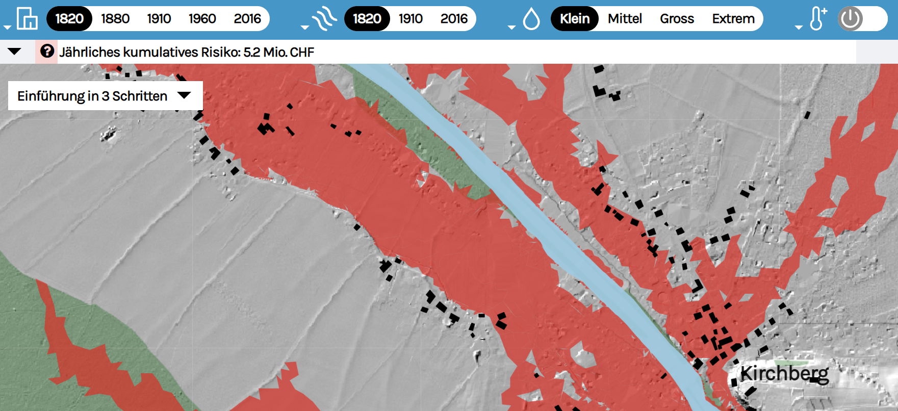
Simulationen mit verschiedenen Szenarien helfen den Behörden und weiteren Fachpersonen zu verstehen, aufgrund welcher Faktoren sich Hochwasserrisiken im Verlauf der Zeit verändern. Auf dieser Grundlage lassen sich geeignete Schutzmassnahmen und raumwirksame Entscheidungen auch zukunftsbezogen planen und umsetzen.
a) Analysieren Sie Veränderungen von Faktoren für Hochwasserrisiken am Beispiel der Emme bei Burgdorf mit dem Tool Risikodynamik.
Hinweis: Steigen Sie mit der «Einführung in 3 Schritten» in das Tool ein. Experimentieren Sie anschliessend mit den vier Reglern zu «Stand Siedlung», «Stand Flusslauf», «Grösse des Hochwassers» und «Klimazuschlag» und beobachten Sie, wie sich dabei das jährlich kumulierte Risiko, das Schadenpotenzial und die Anzahl betroffener Gebäude verändert.
b) Analysieren Sie in hochwassergefährdeten Gebieten Ihrer Gemeinde die Veränderung von Fliessgewässern und Siedlungen seit 1840 mithilfe der Swisstopo-Zeitreise. Diskutieren Sie Wechselwirkungen zwischen Siedlungsentwicklung und Hochwasserrisiken in Ihrer Gemeinde unter Einbezug der aktuellen Gefahrenkarte zu Hochwasser.
c) Geländeaufgabe: Überprüfen Sie bei einer Geländebegehung in Ihrer Gemeinde Ihre Erkenntnisse und Überlegungen zu Hochwasserrisiken und Siedlungsentwicklung in hochwassergefährdeten Gebieten.
Geht man davon aus, dass bis im Jahr 2040 schweizweit ein Drittel der verfügbaren Bauzonenreserven überbaut werden, könnten die gefährdeten Gebäudewerte von 2020 bis 2040 um 5.3 Milliarden Franken zunehmen.
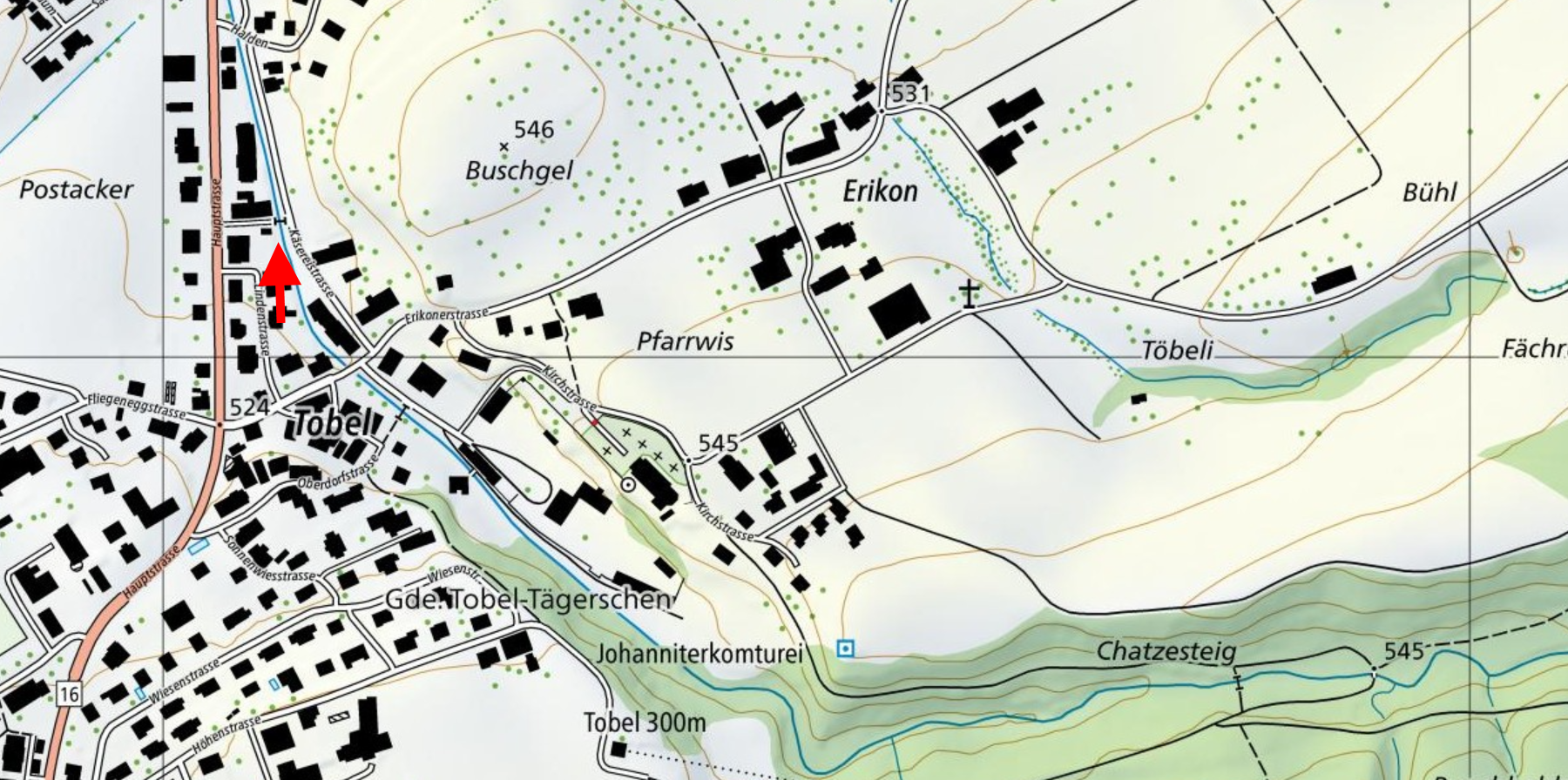
a) Erklären und begründen Sie zu erwartende Veränderungen des Hochwasserrisikos bis ins Jahr 2040 bezüglich Gefahrenpotenzial, Schadenpotenzial und Verletzlichkeit beim Hartenauerbach in der Gemeinde Tobel-Tägerschen (TG) mit Bezug zur folgenden Abbildung.
b) Überprüfen Sie Ihre Überlegungen zur Teilaufgabe a) mit dem Tool Schadensimulator für die Gemeinde Tobel-Tägerschen, für Ihre Gemeinde sowie schweizweit. Begründen Sie regional unterschiedliche Entwicklungen des möglichen Schadenausmasses mithilfe der Informationen im Tool Schadensimulator.
Bemerkung: Vergleichen Sie im Tool Schadensimulator das mögliche Schadenausmass von heute (d. h. bei heutigem Stand der baulichen Verdichtung und des Objektschutzes gegen Hochwasser) mit dem wissenschaftlichen Szenario für das Jahr 2040 (d. h. mit zu erwartender baulicher Verdichtung und umgesetztem Objektschutz).
c) Schlagen Sie Massnahmen beim Hartenauerbach mit Bezug zu obigen Abbildungen vor, welche das Hochwasserrisiko vermindern und erläutern Sie kurz.
d) Testen Sie in Ihrer Gemeinde ein eigenes Szenario mit dem Tool Schadensimulator, indem Sie die bauliche Verdichtung und den umgesetzten Objektschutz im «Eigenen Szenario» selber festlegen. Beurteilen Sie, wie diese einstellbaren Faktoren das mögliche Schadenausmass verändern.
e) Recherchieren Sie auf der offiziellen Website Ihrer Gemeinde und Ihres Kantons, inwiefern die bauliche Verdichtung und der Objektschutz thematisiert, umgesetzt und geplant werden sowie welche gesetzlichen Bestimmungen dazu existieren.
f) Beurteilen Sie ausgehend von Ihrer Gemeinde, wie in Zukunft mit Hochwasserrisiken umzugehen ist. Beziehen Sie bei Ihren Überlegungen das integrale Risikomanagement der Schweiz ein und ordnen Sie die Bedeutung dieses Konzepts für die Zukunft ein.

Tillmann Schulze has been working for around 20 years in the areas of civil protection and the protection of critical infrastructure – in close cooperation with experts from emergency response organisations, administration and the private sector.
Link to high-resolution version of video on YouTube
Tillmann Schulze arbeitet seit rund 20 Jahren in den Themen Bevölkerungsschutz und Schutz kritischer Infrastrukturen - in enger Zusammenarbeit mit Expertinnen und Experten aus Einsatzorganisationen, Verwaltung und Privatwirtschaft.
Link zur hochaufgelösten Version des Videos auf Youtube
Together with the Canton of Berne’s office for civil protection, sport and military affairs (BSM) and the municipality of Burgdorf, Mobiliar Lab conducted a one-day training exercise for the regional leadership body (RFO). Thanks to the new flood dynamics tool, it was possible to simulate a realistic extreme flood scenario including a one-week preparatory phase for the leaders of the fire brigade. The following short film shows the advantages of preventive rather than merely damage-limiting civil protection exercises.
Link to high-resolution version of video on YouTube

Lukas Munz has been working at the Mobiliar Lab for Natural Risks since September 2020. For his doctoral dissertation, he is researching the storyline approach as a way of communicating the complex physical and social interactions inherent in flood events. He is also investigating how his insights can be shared and applied in practice.
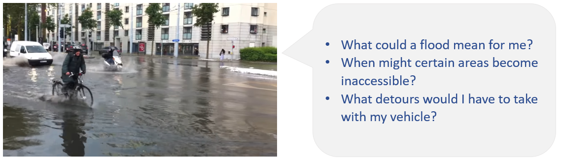
What user groups can apply the Flood Dynamics tool in practice?
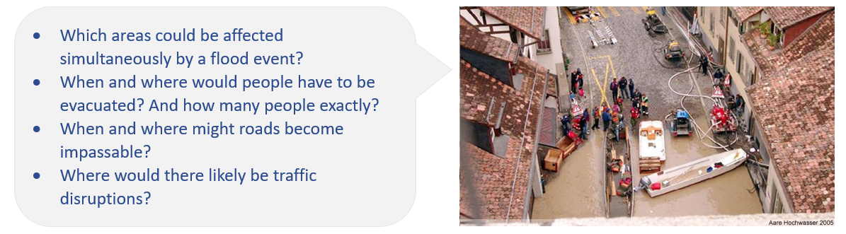
The primary user group is people working in civil protection – from the national level down to the regional and local civilian command teams and the experts who advise them. They can use the tool as an aid in risk communication, training, and operational-level planning.
The tool also addresses other user groups, such as the general public, insurance companies, and the scientific community.
How can the Flood Dynamics tool support civil protection?
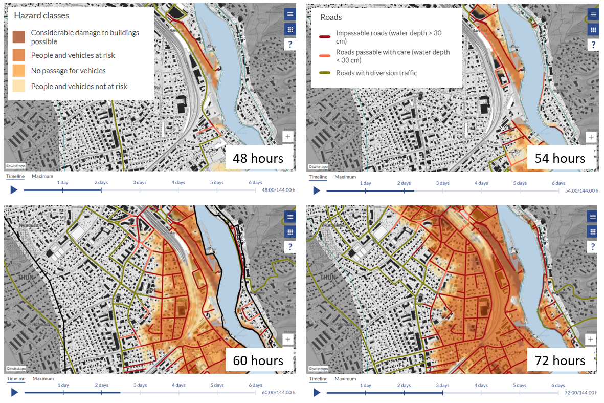
It can support risk communication and risk dialogue, for example. The tool visualises the dynamics of a flood event very vividly in so-called story maps (see the storyline approach). It highlights the chain of processes from the initial precipitation to its possible impacts on people, workplaces, buildings, and roads. The detailed, dynamic visualisation fosters a personal connection and arouses concern. This helps sensitise people to flood risks: personal concern makes it easier to communicate abstract risks. The tool shows vividly how extreme precipitation can affect people.
The tool can provide well-founded flood event scenarios as a basis for scripting civil protection drills. It allows the spatial and temporal dynamics of a large flood to be integrated into a script from the regional level on down to the local level. Such scripts are used in drills for command teams at the cantonal, regional, and municipal levels and in the training of natural hazard advisers.
The tool can provide emergency planners with information that enables them to estimate the order in which specific areas will be affected, and how severely they will be affected. This enables planners to set priorities for resource deployment and to determine early on how long a certain area will remain accessible. In civil protection, the timing of interventions and advance warning is a prime concern.
Can you give us some concrete examples of other uses of the tool?
Logistics companies are interested in knowing the condition of transport routes. A flood’s impact on roads can be estimated from the dynamic visualisation in the tool. It also shows when and to what extent use of a given road might become difficult or impossible. Together with the additional information on diversion traffic, this provides a basis for adjusting route planning and estimating delays.
Hydraulic engineers can assess from a supraregional perspective which weak points should be prioritised for investment in additional protective systems. In addition, the animated visualisation of possible events can complement existing static hazard maps as a means of informing the population and authorities. Sensitising the population can also be helpful for decision-makers, for example in the context of new flood protection projects.
How does the Flood Dynamics tool benefit research?
The Flood Dynamics project is an example of how scientific research can be successfully put into practice together with users. The experience gained in this cooperation is also valuable for planning and implementing other projects.
The tool can be seen as a prototype for the possible combination of meteorological and hydrological forecasts into early warning systems capable of warning not only of events themselves, but also their impacts. Such early warning systems could enable identification of recommended response measures for specific user groups.
The Flood Dynamics tool can serve to explore the possibilities of communicating complex chains of processes using the storyline approach. This, in turn, provides a basis for the systematic study of how users perceive interactive dynamic web tools, and benefits risk communication.
The following four short videos show in detail how today’s and future flood damage can be estimated thanks to the Flood Risk Research Initiative, and how the Flood Damage Simulator offers support for specific practical issues.
Loading the videos may take a moment. Thank you for your patience.

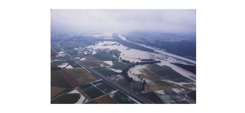
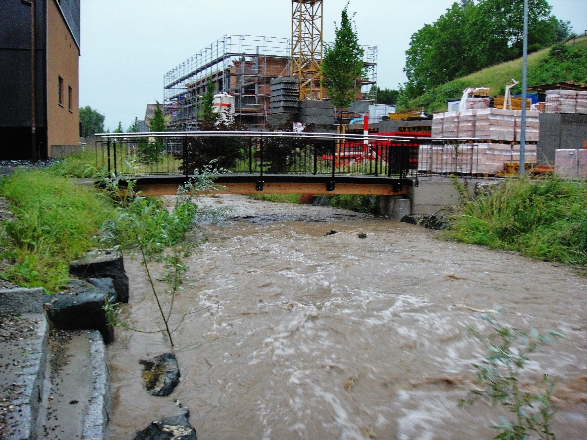
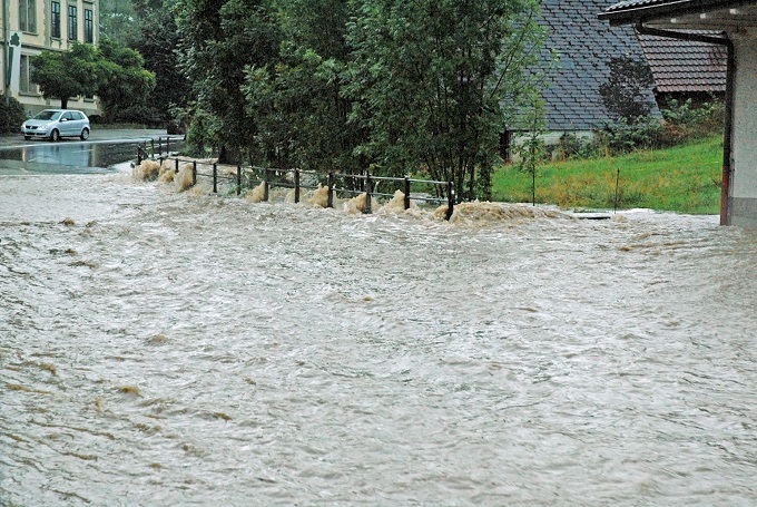
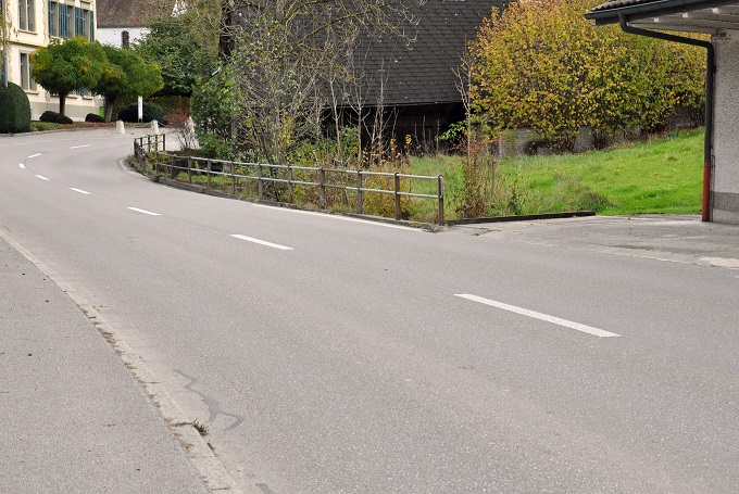
Christian Eicher lives in Melchnau (BE). He has documented several of the flood events that have affected the town and has contributed photos to the Flood Image Memory. Christian, a retired civil engineer, spent much of his career working in flood protection and urban drainage.
To my mind, ‘Flood Image Memory’ perfectly captures the purpose of having these images. Past flood events tend to get forgotten about relatively quickly, or our memories become rose tinted, a bit like our recollections of our military service. Hence we remember just the basic outline but not how lives and livelihoods were impacted. Having these images is extremely important if we want to keep a record of how severe these events were.
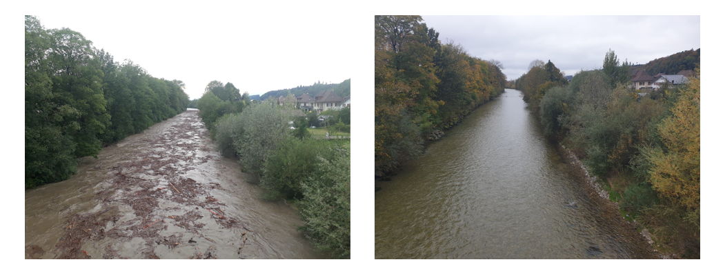
Using the flood images, for example, we can see the high-water marks and recognise the sediment left behind. That helps us to work out the size of the area that flooded. Images from similar locations can therefore be used to state approximately how extensively and how often flooding occurs in a given area, although different boundary conditions such as obstacles to drainage, wider openings and bridges also need to be taken into account. Additionally, flood images can also be used to provide parameters for computer simulations, as long as local rainfall data is also available.
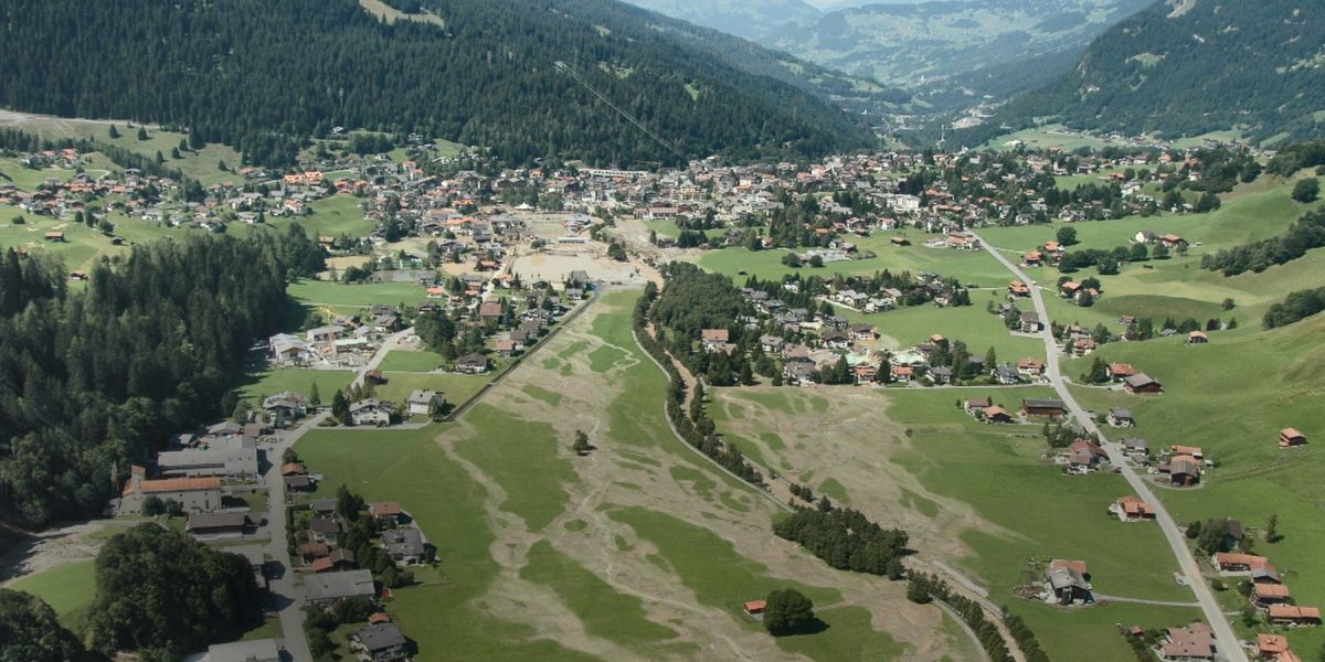
In Melchnau the images have helped show just how frequent and devastating the flooding has been in the past (see pictures dating from 1986, 2007 and 2010 on this page). The need for further structural measures, such as flood defences and expansions of waterways, had to be proven and these photos were useful in that respect. It stands to reason that they can also be used for raising awareness among homeowners as to how they can protect their personal possessions. Today, various defence systems are being planned in Melchnau to minimise the potential damage from flooding.

“The flood damage potential is above the Swiss national average in the area we cover. Thanks to the new movable floor barrier, we are even better equipped to deal with this hazard.”
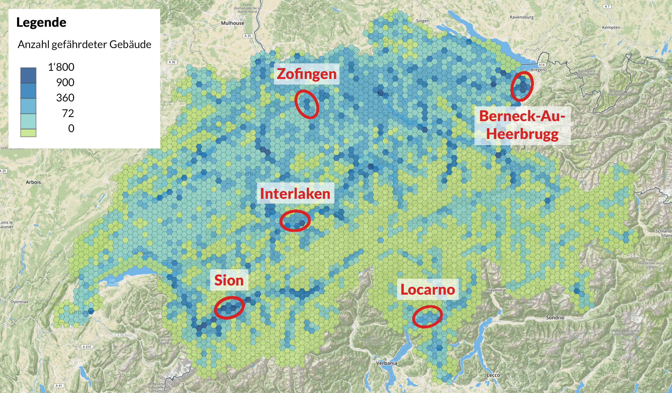
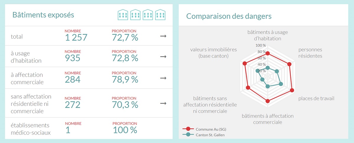
Water is a dominant feature of the landscape in the St Gallen region, with countless streams coursing into the Rhine on the floor of the valley. This particular geography is reflected by the flood hazard map, with large areas marked as being exposed. To determine the potential damage that could be brought on these places, we obviously need to know about the hazards but also certain information about what is located there. The damage potential map can be enlarged all the way down to neighbourhood level, showing the number of buildings located in the flood hazard zones and the value of these buildings. The map also indicates where jobs are affected and where public facilities such as hospitals, schools and retirement homes are exposed.
Analysis of the nationwide potential damage shows that some 1.3 million people live in buildings exposed to flooding. The number of jobs threatened by flooding is almost as high. Places particularly exposed are mainly located in and around Interlaken, in the Rhone Valley between Brig and Lake Geneva, and in the St Gallen Rhine Valley. Here the flood damage potential map shows that almost three-quarters of buildings are exposed, and indeed around one in six of these is located in either medium or a highly exposed area.
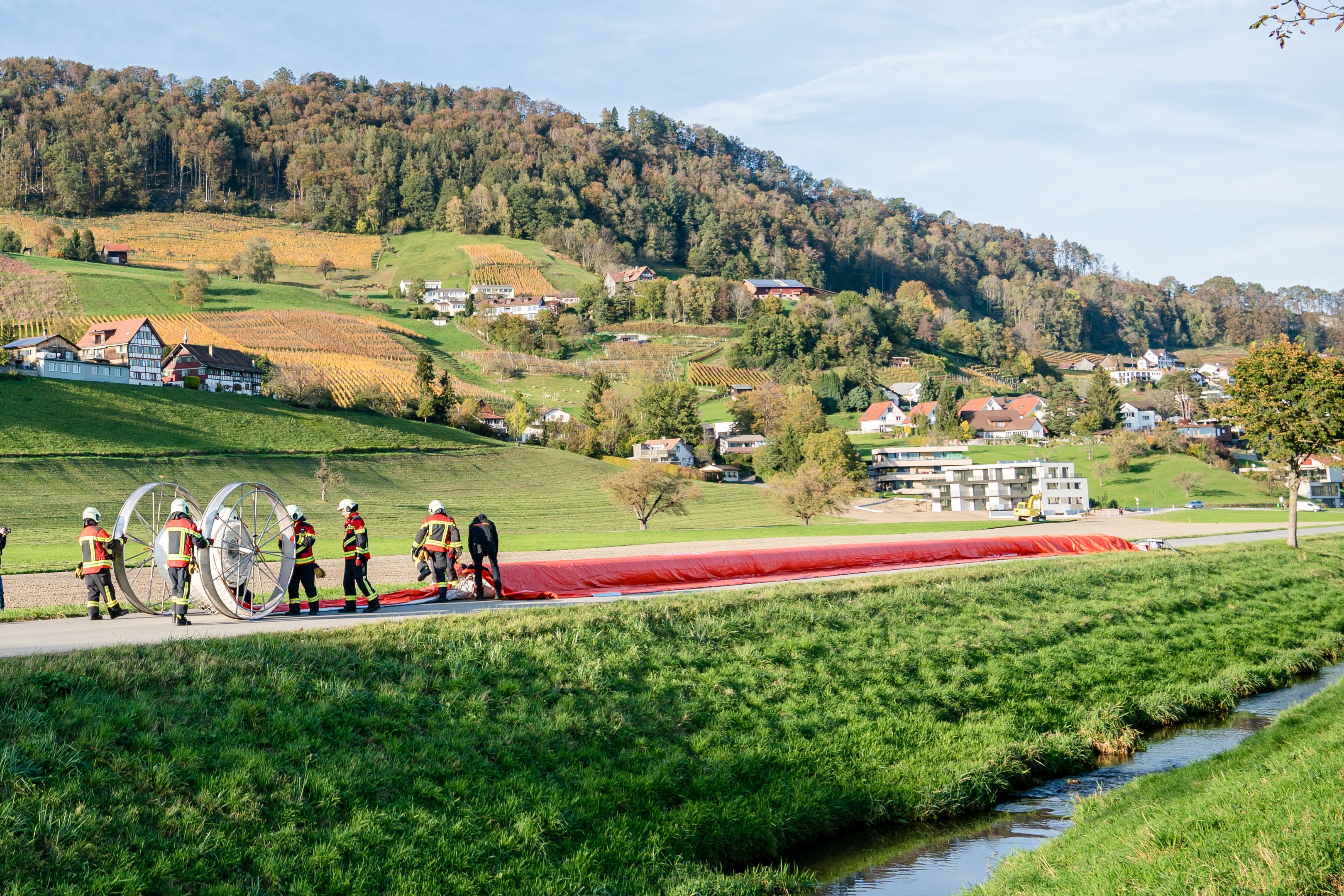
To protect areas such as the St Gallen Rhine Valley that are facing an above-average exposure of flooding, it is essential to identify what could be damaged and where it is located. Once this is known, effective protective measures can be taken. As important as permanent structural measures are, processes enabling local emergency services to combat the rising floodwaters effectively are also needed. Mobile protection systems are one such example. Using the damage potential map, Swiss Mobiliar identified five highly exposed areas in 2019 and provided each of the local professional fire brigades with a container load of movable flood barriers. One of the fire brigades receiving this equipment was the team in Berneck-Au-Heerbrugg.
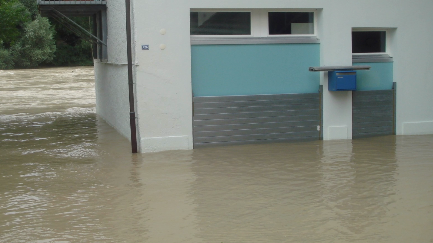
The movable flood barrier can be quickly moved into place in the event of rising floodwaters and set up however required. The tubing is filled with water and the barrier can then be used over a length spanning several hundred meters. That helps to prevent flood damage in places where the most dwellings or businesses are located.
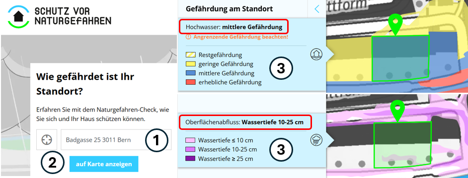
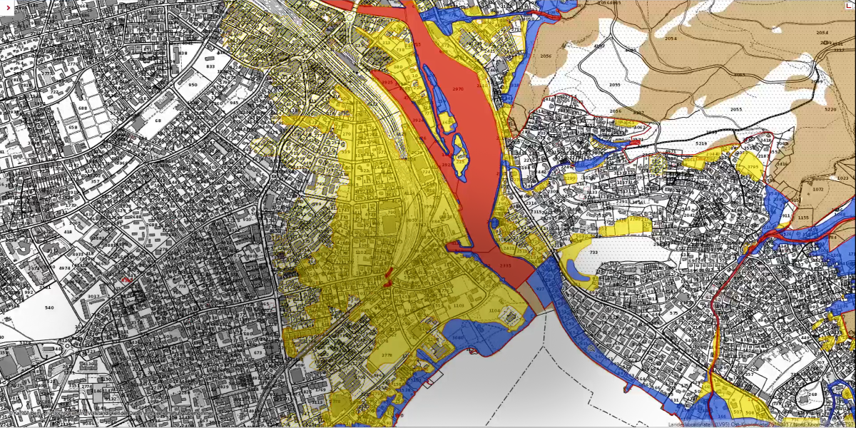
The cantonal hazard map for water provides detailed information on the flooding threat at different danger levels. The hazard maps are incorporated into municipal land use planning. Construction is prohibited in the red hazard zone. In the blue zone, construction permits are only granted subject to conditions, and recommendations can be made in the yellow zone with a low hazard level for existing buildings and conditions imposed for new constructions.
The surface runoff risk map presents areas susceptible to surface runoff in a rare (one-in-a-100-year) event. The map facilitates an initial rough estimate of the possible flooding depth through overland flow. The surface runoff risk map is not incorporated in municipal land use planning.
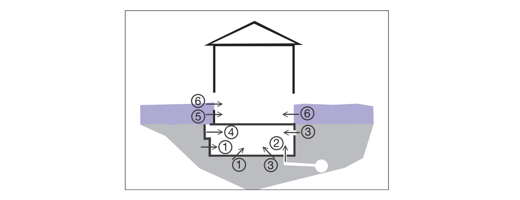
Using the website “Protection from natural hazards» (available in French and German), you can easily determine the water-related hazard level and overland flow for a specific location (1) (see Figure 1). By clicking “auf Karte anzeigen” (show on map) (2) and then activating the “Hochwasser” (flooding) or “Oberflächenabfluss” (overland flow) tile (3), the flood hazard zone or flow depth level for surface run-off will be displayed. Alternatively, you can infer the hazard zone directly from the cantonal natural hazard map.
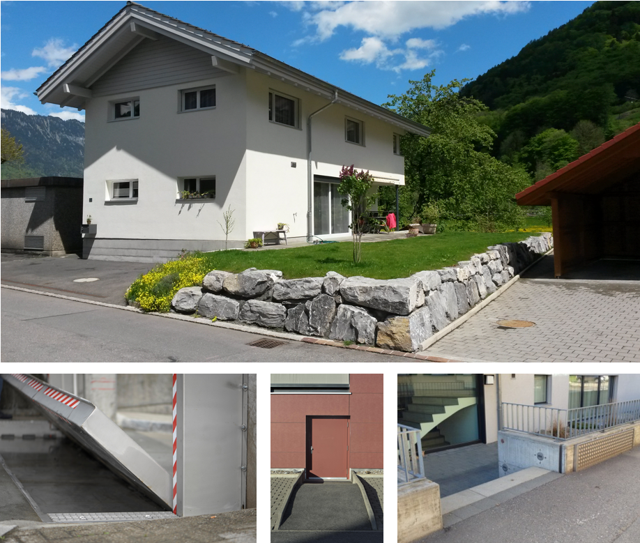
Property owners can take flood protection measures to protect their property/building to prevent or mitigate damage from flooding or overland flow. Owners can initiate these measures themselves. The potential for damage can be significantly reduced with reasonable effort. Therefore, these measures generally offer an attractive cost-benefit ratio.
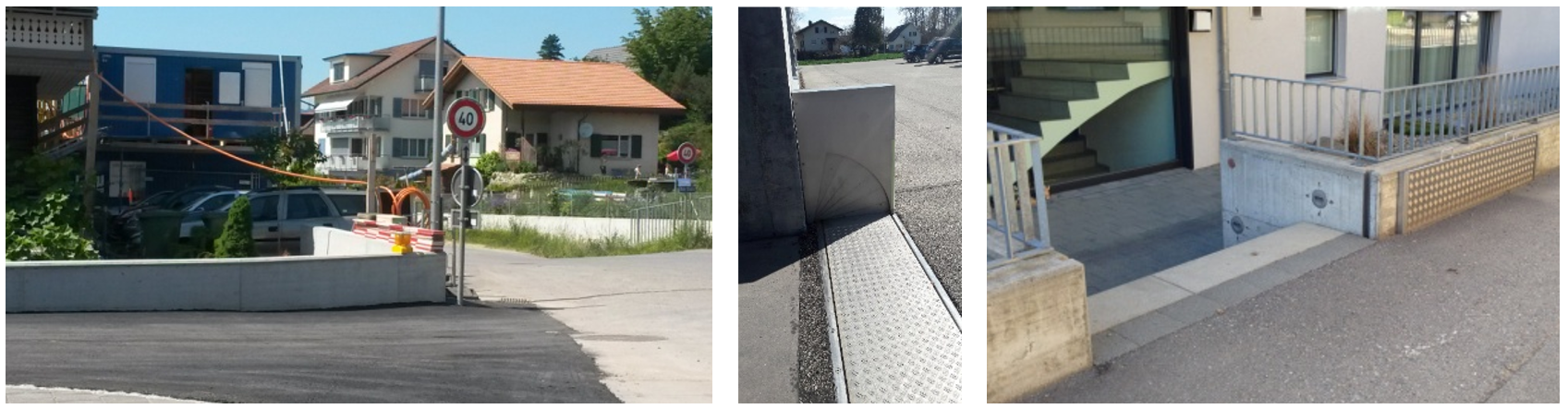
Property-level flood protection measures comprise the following (see Figure 2):
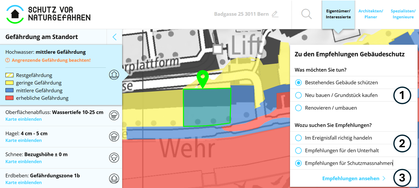
The website “Protection from natural hazards” provides an overview of possible property-level flood protection measures. If you select any of the options under (1) and (2), you will access the recommendations for flood protection measures (3) (see Figure 3).
The recommendations can be configured in a further step. Select the natural hazard “Hochwasser” (flooding) and “Oberflächenabfluss” (overland flow) for an overview of possible measures.
A specialist must be consulted for the specific planning of flood and overland flow protection measures. Contact details for expert advice can be found at the agency responsible for natural hazards or the building insurance for your canton.
To plan suitable flood and overland flow protection measures for your property, the so-called effective height must be known. This determines the height to which the building should be protected. In a further step, an expert must determine ways in which water could enter the building on site (see Figure 4). For new constructions, compliance with SIA standards 261 and 261/1 is also required.
The platform “Protection from natural hazards” provides links to the cantonal agencies responsible for natural hazards and flood protection in Switzerland. Here, you can also find cantonal and municipal protection goals, as well as property-level flood protection measures prescribed by the cantons and municipalities.
As the costs incurred are usually much lower than the potential damage of a flooding or overland flow event, the cost-benefit ratio is high.
If flood protection measures for a new construction are incorporated at an early stage, the extra costs are usually minor or even negligible. In addition, these measures can be integrated discreetly into the building and landscape design.
The study Implementation of property-level flood risk adaptation (PLFRA) measures: Choices and decisions (Attems et al., 2019) provides a rough overview of the costs of flood protection measures, although the costs do not match current price levels in Switzerland. For example, a stop log system to keep water away from an entrance would likely cost a low four-digit Swiss franc amount. Sealing a light shaft can cost just under one thousand francs.
You should also find out whether it is possible to obtain financial support for implementing flood protection measures for buildings in your canton. For example, building insurance in the canton of Bern contributes 80% of eligible costs, provided it is compatible with the cost-benefit ratio.
The Mobiliar Lab has examined the effect of property protection measures and successfully demonstrated that such measures can significantly reduce the risk. The following studies provide further information:
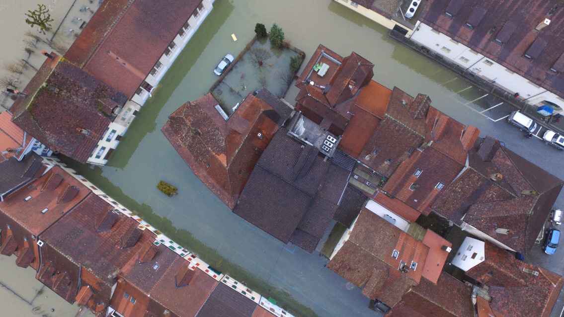
Cover picture: Chevroux (VD), 2015
Picture credits: Mobiliar Lab für Naturrisiken / Bruno Schädler / CC BY-SA 4.0; Image link
Tool image damage potential: Screenshot of the tool (edited)
Picture credits: © Mobiliar Lab für Naturrisiken
Tool image flood memory: Image collage with images from the tool (from top left to bottom right)
Tool image risk dynamics: Screenshot of the tool (edited)
Picture credits: © Mobiliar Lab für Naturrisiken
Images of Building protection guide:
Picture credits: © Mobiliar Lab für Naturrisiken